Guide to GNSS (Global Navigation Satellite System) Usage
Introduction to GNSS:
Global Navigation Satellite Systems (GNSS) are satellite-based technologies that provide positioning, navigation, and timing (PNT) services to users anywhere on the Earth's surface. The most well-known GNSS is the Global Positioning System (GPS), but other major systems include GLONASS (Russia), Galileo (European Union), BeiDou (China), and regional systems like QZSS (Japan) and NavIC (India). GNSS is crucial in various industries, including surveying, agriculture, transportation, aviation, and defense, among others.
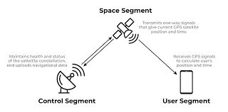
1. Understanding GNSS Components
GNSS consists of three primary segments:
Space Segment:
- This includes the satellites orbiting Earth, transmitting signals that carry information about their location and time.
- Satellites are positioned in medium Earth orbit (MEO) to provide continuous global coverage.
- Each system has its constellation (e.g., GPS has 31 active satellites, GLONASS has 24, Galileo has 22, and BeiDou has 35).
Control Segment:
- Ground stations that monitor satellite health, orbit, and timing.
- They control satellite orbits and ensure the signals are accurate and synchronized.
User Segment:
- Consists of GNSS receivers that pick up satellite signals to determine a user’s position, velocity, and time (PVT).
- Receivers vary from simple handheld devices to complex systems integrated into vehicles, aircraft, and industrial machinery.
2. How GNSS Works
Signal Transmission:
- Each satellite continuously broadcasts a signal that includes its location (ephemeris), precise time, and satellite health status.
- Signals travel at the speed of light to GNSS receivers on Earth.
Position Calculation (Trilateration):
- The receiver calculates its distance from multiple satellites by measuring the time it takes for signals to travel from each satellite to the receiver.
- Using signals from at least four satellites, the receiver calculates its precise 3D position (latitude, longitude, altitude) and time correction.
Error Correction:
- GNSS systems include corrections for various errors like atmospheric interference, clock inaccuracies, and multipath errors (signals bouncing off surfaces).
- Advanced receivers also use Differential GNSS (DGNSS) and Real-Time Kinematic (RTK) corrections to improve accuracy.
3. Types of GNSS Systems
GPS (Global Positioning System):
- Managed by the United States Department of Defense.
- Provides global coverage with 31 active satellites.
- Standard Positioning Service (SPS) for civilian use and Precise Positioning Service (PPS) for military use.
GLONASS (Global Navigation Satellite System):
- Operated by Russia.
- Consists of 24 satellites offering global coverage.
- Works well in high latitudes due to its orbital arrangement.
Galileo:
- Managed by the European Union.
- Currently has 22 operational satellites with plans for 30.
- Provides high accuracy and is independent of other systems.
BeiDou:
- Managed by China, with 35 satellites providing global and regional coverage.
- Offers unique features like short message communication.
NavIC (Navigation with Indian Constellation):
- Regional GNSS developed by India.
- Provides accurate position information to users in India and surrounding regions.
QZSS (Quasi-Zenith Satellite System):
- Regional system developed by Japan.
- Enhances GPS performance, particularly in urban areas with high-rise buildings.
4. GNSS Applications in Different Industries
Surveying and Mapping:
- High-precision GNSS receivers are used for land surveying, geodesy, and construction projects.
- Technologies like RTK GNSS can achieve centimeter-level accuracy, crucial for setting boundaries and construction layouts.
Agriculture (Precision Farming):
- GNSS is used for tractor guidance, variable rate application of fertilizers, and crop yield mapping.
- Reduces input costs and increases crop yields by optimizing field operations.
Transportation and Fleet Management:
- GNSS is widely used in navigation systems for cars, trucks, ships, and airplanes.
- Fleet management systems use GNSS for route optimization, fuel efficiency, and real-time tracking of vehicles.
Aviation:
- Enhances navigation, landing approaches, and air traffic management.
- GNSS-based systems like WAAS (Wide Area Augmentation System) improve flight safety and efficiency.
Maritime Navigation:
- Used for vessel tracking, navigation, and collision avoidance.
- Improves safety and efficiency in shipping and fishing industries.
Telecommunications:
- Provides accurate timing for synchronizing networks, crucial for data transmission and mobile phone operations.
Defense and Security:
Military uses encrypted GNSS signals for navigation, missile guidance, and situational awareness.
5. Enhancing GNSS Accuracy
Differential GNSS (DGNSS):
- Involves using a network of fixed ground stations to provide corrections to the GNSS signals, improving accuracy to the sub-meter level.
Real-Time Kinematic (RTK):
- Uses carrier phase measurements and a base station to provide corrections, achieving centimeter-level accuracy.
- Commonly used in surveying, agriculture, and machine control applications.
Precise Point Positioning (PPP):
- Uses precise satellite orbit and clock data to provide corrections without the need for a nearby base station.
- Achieves accuracies in the decimeter range and is ideal for remote locations.
Augmentation Systems:
- SBAS (Satellite-Based Augmentation Systems): Systems like WAAS (USA), EGNOS (Europe), and GAGAN (India) enhance GNSS accuracy by providing corrections through geostationary satellites.
- GBAS (Ground-Based Augmentation Systems): Provides corrections and integrity monitoring of GNSS signals near airports, enhancing aviation safety.
Selection tips for GNSS receiver for Surveyor
Selecting the right GNSS (Global Navigation Satellite System) receiver is crucial for surveyors, as it directly impacts the accuracy, reliability, and efficiency of fieldwork. Here are comprehensive tips to guide you in choosing the best GNSS receiver for surveying tasks:
1. Determine Your Surveying Needs
- Type of Surveying Work: Identify the nature of your work—construction staking, cadastral surveys, topographic mapping, geodetic surveys, or GIS data collection. Different tasks require varying levels of accuracy and equipment capabilities.
- Accuracy Requirements: Determine the level of accuracy required for your projects. For high-precision applications like boundary surveys, you may need sub-centimeter accuracy, while less demanding tasks may require meter-level accuracy.
- Survey Environment: Consider the environment in which you will be working—urban, rural, forests, mountains, or open fields. Challenging environments with obstructions like buildings, trees, or canyons require receivers with better multipath rejection and signal tracking capabilities.
2. Choose the Appropriate GNSS Technology
- Multi-Constellation Support: Opt for receivers that can track multiple GNSS constellations such as GPS, GLONASS, Galileo, and BeiDou. Multi-constellation receivers provide better signal availability and accuracy, especially in challenging environments.
- RTK (Real-Time Kinematic) Capability: For high-precision surveys, select a receiver with RTK capability, which provides centimeter-level accuracy in real time using correction data from a base station or network.
- PPK (Post-Processing Kinematic): If real-time corrections are not available or reliable, consider receivers that support PPK, allowing you to achieve high accuracy by processing data after collection.
- SBAS (Satellite-Based Augmentation System): Receivers with SBAS support (e.g., WAAS, EGNOS) offer improved accuracy and integrity by providing correction data from satellites, ideal for less critical tasks where RTK is not required.
3. Evaluate Receiver Performance Specifications
- Signal Tracking and Sensitivity: Check the number of channels and the receiver’s ability to track weak signals under challenging conditions like dense canopy or urban canyons. High-sensitivity receivers with more channels offer better performance.
- Multipath Rejection: Look for receivers with advanced multipath rejection technology to reduce errors caused by signals reflecting off nearby surfaces.
- Positioning Update Rate: A higher update rate (e.g., 10 Hz or more) allows for smoother data collection and is particularly useful when measuring moving targets or dynamic surveys.
4. Assess Receiver and Antenna Quality
- Integrated vs. External Antennas: Integrated antenna systems are compact and easy to use but may not perform as well in multipath environments. External antennas allow for more flexible setups and often provide better signal quality, especially with choke ring or geodetic-grade antennas.
- Antenna Type: Ensure the antenna is capable of tracking all available signals (L1, L2, L5, etc.) and has good phase center stability to minimize errors.
- Antenna Mounting: Consider receivers with rugged and versatile antenna mounts that can be easily set up on tripods, poles, or vehicles.
5. Connectivity and Data Handling
- Data Communication Options: Look for receivers with versatile communication options, including Bluetooth, Wi-Fi, USB, and serial ports, for easy connection to data collectors, computers, and other devices.
- Correction Services Compatibility: Ensure the receiver can connect to various correction services such as NTRIP, VRS networks, or radio links for RTK corrections.
- Data Storage and Export Formats: Receivers should support multiple data formats (RINEX, CSV, DXF, etc.) and offer sufficient onboard storage or the ability to use external storage like SD cards.
- Cloud Connectivity: Some modern receivers offer cloud connectivity for seamless data transfer and remote management, enhancing productivity.
6. Software Compatibility and Integration
- Survey Software Compatibility: Ensure the GNSS receiver is compatible with the survey software you use (e.g., Trimble Access, Leica Captivate, Carlson SurvCE, etc.). Integration with your preferred software streamlines fieldwork and data processing.
- Ease of Use: Consider receivers with intuitive user interfaces and easy integration with handheld data collectors, tablets, or smartphones. Easy setup and operation reduce the learning curve and enhance field efficiency.
7. Durability and Field Suitability
- Ruggedness: Choose a receiver built to withstand harsh field conditions, including dust, water, shock, and temperature extremes. Look for equipment with high IP ratings (e.g., IP67) for water and dust resistance.
- Battery Life: Ensure the receiver has sufficient battery life to last through your typical fieldwork day. Look for swappable battery options to minimize downtime.
- Portability: Consider the weight and size of the receiver, especially if you need to carry it over long distances or rough terrain. Compact, lightweight models are easier to transport and set up.
8. Manufacturer Reputation and Support
- Brand Reputation: Opt for established brands known for quality, reliability, and excellent customer support, such as Trimble, Leica, Topcon, and Spectra Precision.
- Warranty and Service: Check the warranty terms and availability of service centers. Ensure that spare parts, accessories, and repairs are easily accessible.
- User Community and Training: A strong user community and access to training resources can be valuable for troubleshooting, learning, and maximizing the use of your GNSS equipment.
9. Cost Considerations
- Budget Constraints: Define your budget but consider that investing in a higher-quality receiver with better features and durability can save costs in the long run due to fewer repairs, downtime, and the need for future upgrades.
- Total Cost of Ownership: Factor in the costs of accessories (antennas, poles, batteries), software licenses, correction services, and potential repair costs when evaluating the total investment.
- Scalability: Choose a receiver that can grow with your needs, offering upgradable features like additional signal tracking, software updates, or compatibility with new correction services.
10. Field Tests and Feedback
- Test Before Purchase: Whenever possible, test the receiver in the field under your typical working conditions to ensure it meets your requirements.
- Read Reviews and Get Feedback: Seek feedback from other surveyors or colleagues who have experience with the GNSS receivers you are considering. Online forums, reviews, and professional groups can provide valuable insights.
Conclusion
Selecting the right GNSS receiver involves balancing performance, accuracy, durability, and cost. By carefully assessing your specific needs, considering advanced GNSS capabilities, and evaluating the receiver’s overall performance in the field, you can make an informed decision that enhances your surveying operations. Investing in the right equipment ensures high-quality results, efficiency, and a smooth surveying experience.
7. Setting Up and Using a GNSS Receiver
Initial Setup:
- Charge the receiver and ensure firmware is updated.
- Set the receiver to track the desired GNSS constellations (e.g., GPS, GLONASS).
- Configure settings for data logging, accuracy, and coordinate system preferences.
Positioning and Data Collection:
- Place the receiver in a clear area with minimal obstructions for optimal satellite signal reception.
- For high-precision work, use a tripod or survey pole to stabilize the receiver.
- Initiate data logging, ensuring sufficient data points are collected for accuracy.
Correction Services:
- Connect to correction services like RTK networks or SBAS to enhance positioning accuracy.
- For RTK, ensure a reliable communication link between the base station and rover (receiver).
Data Post-Processing:
- If real-time corrections aren’t available, data can be corrected post-survey using post-processing software.
- Upload raw GNSS data to software platforms that apply corrections from reference stations for improved accuracy.
8. GNSS Challenges and Solutions
Multipath Interference:
- Occurs when GNSS signals reflect off surfaces like buildings, causing errors.
- Solution: Use receivers with advanced multipath mitigation technology.
Signal Obstructions:
- Dense foliage, tall buildings, or tunnels can block signals.
- Solution: Use multi-frequency receivers or integrate with IMUs for dead-reckoning navigation when signals are lost.
Ionospheric and Atmospheric Delays:
- Can cause signal delays and positional errors.
- Solution: Use dual-frequency receivers that can correct for ionospheric errors.
Jamming and Spoofing:
- GNSS signals are weak and susceptible to interference from jammers or spoofers.
- Solution: Use anti-jam antennas and receivers with anti-spoofing features.
9. Best Practices for GNSS Use
Regularly Update Firmware:
- Keeps the receiver compatible with the latest satellites and correction services.
Calibrate Equipment:
- Periodically check and calibrate survey poles, antennas, and other equipment to maintain accuracy.
Use Quality Antennas:
- A good antenna can significantly reduce errors, especially in challenging environments.
Environmental Awareness:
- Be mindful of weather conditions, as heavy rain or solar storms can affect signal quality.
Conclusion
GNSS technology is a cornerstone of modern positioning
Maintenance tips for GNSS system
Maintaining a GNSS (Global Navigation Satellite System) system is crucial for ensuring its accuracy, reliability, and longevity. Proper maintenance minimizes errors, reduces downtime, and maximizes the performance of GNSS receivers, antennas, and other associated equipment. Below are some comprehensive maintenance tips for keeping your GNSS system in optimal working condition:
1. Regular Inspection and Cleaning
- Inspect the Hardware Regularly: Check the GNSS receiver, antenna, cables, and mounting hardware for signs of physical damage, corrosion, or wear and tear. Look for loose connections, cracks, or broken parts that could affect performance.
- Clean the Antenna and Receiver: Dirt, dust, and debris can accumulate on the antenna and receiver, interfering with signal quality. Clean these components regularly using a soft cloth, avoiding harsh chemicals that could damage sensitive electronics.
- Protect Connectors: Ensure that connectors are clean, dry, and free from debris. Use protective caps when the equipment is not in use to prevent contamination.
2. Antenna Maintenance
- Check Antenna Placement: Ensure the antenna is mounted in a clear, unobstructed location away from metallic objects, structures, or reflective surfaces that could cause multipath errors. Verify that it is level and securely mounted.
- Inspect Cables and Connectors: Regularly check antenna cables for cuts, kinks, or signs of wear that could degrade signal quality. Replace damaged cables immediately. Ensure connectors are tightly secured and free from corrosion.
- Test Antenna Functionality: Periodically test the antenna’s performance using diagnostic tools to ensure it is functioning correctly. Replace the antenna if there are consistent signal reception issues.
3. Firmware and Software Updates
- Update Firmware Regularly: GNSS receivers often receive firmware updates that improve performance, fix bugs, and add support for new satellites or signal corrections. Check for updates regularly from the manufacturer’s website and install them promptly.
- Upgrade Correction Service Settings: Ensure that your receiver’s configuration settings align with the latest GNSS corrections and augmentation services (RTK, SBAS, etc.). Updating these settings can improve accuracy and reliability.
- Use Compatible Software: Use the latest compatible software versions for data processing and analysis. Outdated software may not support new features or correction data.
4. Calibration and Testing
- Calibrate Regularly: Regular calibration of GNSS equipment, especially when used in precision applications like surveying, is crucial. Calibration helps correct any drift in the positioning data over time.
- Routine Testing of Equipment: Conduct routine tests in known locations with known coordinates to verify the GNSS system's accuracy. Compare measured positions with known coordinates to detect any deviations.
- Use Diagnostic Tools: Utilize built-in diagnostics and test functions of the receiver to check system health, signal quality, satellite tracking, and other critical parameters.
5. Battery and Power Management
- Check Battery Health: If your GNSS system relies on batteries, regularly check their health, capacity, and charging status. Replace batteries that show signs of swelling, reduced capacity, or rapid discharging.
- Keep Spare Batteries and Power Cables: Always have spare batteries and power cables available, especially when operating in remote locations. This ensures uninterrupted operation in case of power failures.
- Use Quality Power Sources: Ensure that the power sources used are stable and meet the receiver’s voltage and current requirements. Avoid using damaged or unreliable power sources, as they can harm the receiver’s electronics.
6. Environmental Protection
- Protect from Extreme Weather: GNSS equipment can be sensitive to extreme temperatures, humidity, and precipitation. Use weatherproof covers or housings when operating in harsh environmental conditions.
- Avoid Physical Impacts: Protect the GNSS equipment from drops, shocks, or vibrations, which can damage internal components. Use shock-absorbing mounts for antennas and secure all equipment during transportation.
- Shield from Electromagnetic Interference (EMI): Keep the receiver and antenna away from sources of EMI, such as high-power radio transmitters, radar, or electrical equipment, which can disrupt GNSS signals.
7. Data Management and Storage
- Backup Data Regularly: Regularly back up the data collected by your GNSS receiver. Store copies on multiple devices or cloud storage to prevent data loss due to device failures.
- Organize Data Files: Keep your GNSS data organized and labeled clearly. Use standardized naming conventions and formats to make it easier to access and analyze data later.
- Clear Memory Storage: Periodically clear old or unnecessary data from the receiver’s internal memory to prevent storage issues. Ensure critical data is transferred before deleting.
8. Troubleshooting Common Issues
- Signal Loss or Weak Signal: Check for obstructions around the antenna and ensure it has a clear view of the sky. Inspect cables and connections for damage.
- Position Drift or Inaccurate Data: Verify that the receiver is using the correct correction service settings (RTK, DGPS). Check for multipath interference from nearby reflective surfaces.
- Slow Satellite Acquisition: Ensure that the receiver’s almanac data is up-to-date. Perform a cold start or factory reset if satellite acquisition remains slow.
- Error Messages: Refer to the user manual for any error codes displayed by the receiver. Most errors can be resolved by resetting the device, checking connections, or updating firmware.
9. Record-Keeping and Documentation
- Maintain a Maintenance Log: Keep a detailed record of all maintenance activities, including inspections, updates, calibrations, and repairs. Document any issues encountered and actions taken to resolve them.
- Equipment Inventory: Keep an inventory of all GNSS equipment, including serial numbers, purchase dates, and warranty information. This helps in managing replacements and warranty claims.
- User Manuals and Support Contacts: Keep user manuals, technical guides, and contact information for support readily accessible. This ensures quick troubleshooting and efficient maintenance.
10. Professional Maintenance and Servicing
- Annual Professional Servicing: Consider sending GNSS equipment for professional servicing annually or as recommended by the manufacturer, especially for high-precision applications.
- Manufacturer Support and Warranty: Utilize manufacturer support for troubleshooting, repairs, and warranty claims. Keep equipment registered with the manufacturer for updates and recall notices.
Conclusion
Proper maintenance of GNSS systems is essential for ensuring accurate, reliable, and uninterrupted performance. Regular inspections, timely updates, environmental protection, and proper handling practices are key to prolonging the lifespan of your GNSS equipment. By adhering to these maintenance tips, you can significantly reduce the risk of errors, minimize downtime, and enhance the overall effectiveness of your GNSS system.